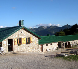
MALGA CONFIN
The farm restaurant “Malga Confin”, recently renovated, is located at 1330 m a.s.l. on the border with the Prealpi Giulie Natural Park and during the summer months it is managed by the commercial farm Azienda Agricola Colomba Ennio.
Its incredible landscape offers a beautiful view, where you can admire a unique variety of plants and animals. Looking up, it is possible to see roe deers and chamois and, hopefully, also Alpine ibexes and even the golden eagle. From the malga you can access to nature trail of Mount Plauris, along which it is possible to see botanical gems as gentians, lilies, edelweiss and orchids. You can assist to the daily milk processing for the production of cheese and all milk products, or even practice hiking of different difficulty levels. The “horse baptism” on Mitzie, the horse of the house, is very appreciated by children.
It is also possible to taste local dairy products (even direct sales) and other traditional products, as gnocchi alla ricotta or polenta e frico (a typical dish based on cheese), together with a great variety of homemade desserts and flavoured grappa (alcoholic beverage).
ACCESS: From Venzone, follow the road that goes up to Val Venzonassa and, having passed the houses of Borgo Prabrunello, turn left on the dirt road, which is occasionally paved with concrete. On the high-altitude crossroad, by turning right, you will shortly reach Malga Confin.
CONTACTS: +39 0432 1821551 – +39 348 5808397 – info@altulin.com – www.altulin.com
SHELTER CJARIGUART
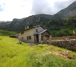
It is located in Val Lavaruzza in the Municipality of Venzone at 1400 m a.s.l. and it is part of the group of the Mount Plauris. It can be reached from Bivacco Franz in 2 hours and from malga Ungarina in about 2 hours and 30 minutes.
The name Cjariguart or Cjadiguart, as we find in old maps, probably comes from the word “Cjare” = goat e “guart” = closed corral, enclosure and indicates the upper part of Val Lavaruzza, a large valley between the two chains of Soreli Mountains– Laraset and Somp Selve – Cervada, ending in the east, with the summit of Mount Plauris.
The austere and wild aspect of the lower section of the valley becomes more gentle by climbing across the steep beginning of the Pares, to the edge of the valley of Cjariguart, where gravels, boulders, slabs and rocky formations serve as a background for the fertile alpine pastures enriched with fresh springs.
Within the valley, rests of ancient dry-stone constructions and a crucifix carved into a rocky spur in 1651 witness the ancient and symbolic presence of man in these charming places. The place has been used since the last century for summer grazing activities, as it used to house a municipal malga built in 1896, with 50 livestock units, mainly cattle and goats, which used the pre-summer pastures of Casere del Plan dai Portolans and Cuel de Fratte.
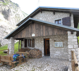
Afterwards, the malga was no longer used as such, but as a shelter. Then, several avalanches destroyed the building, which has been replaced by a new construction: today, the shelter Cjariguart is composed by a welcoming masonry structure with 15 beds, always open to the public and maintained thanks to the volunteers from Venzone. Running water, active solar panels, an outdoor septic bathroom and a vegetable garden cultivated by volunteers make the Shelter Cjariguart as the perfect “base camp” for every kind of excursion.
ACCESS: You can reach shelter Cjariguart on foot from Portis di Venzone (CAI trail no. 728/a), from Località Tugliezzo (CAI trail no. 701), and from Malga Ungarina (CAI trails no. 705 and 728/a).
Type: open to everyone, not managed
Altutude: 1400 m a.s.l.
Location: Val Lavaruzza – Mount Plauris
Trails: CAI trail no. 701 from Località Tugliezzo, CAI trails no. 705 and 728/a from Malga Ungarina
Duration: 2 hours from Bivacco Franz and about 2 hours and 30 minutes from Malga Ungarina.
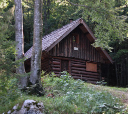
BIVOUAC FRANZ
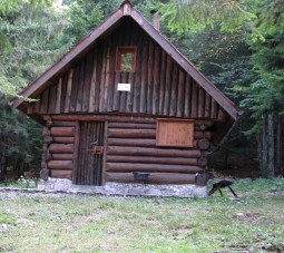
Bivouac FRANZ
It is a small hut made of logs and larch shingles placed above the village of Tugliezzo in the Municipality of Venzone, on the north western slopes of Mount Plauris, at 1000 m a.s.l.
It is located in a small clearing in the woods of the deep valley of Rio Lavarie, between the summit of Larici and the mount Cjucis, is open to everyone and is not managed.
It used to be a hunter shelter and today it can be easily reached trough trail CAI no. 701 from Tugliezzo. It is a popular destination visited throughout the year and used as a departing point for excursions to Mount Plauris.
The structure is almost completely immersed in a large beech forest (Fagussylvatica) which nearly covers all surrounding mountainsides.
The shelter is inside the Botanic Trail of Mount Plauris, which has an access exactly at this point. From here, you have to climb towards pass Maleet always along CAI trail no. 701 and then the path continues up to the summit of mount Plauris or to Casera Cjariguart.
Type: open to everyone, not managed
Altitude: 1034 m a.s.l.
Location: Rio Lavarie – Località Tugliezzo
Trails: CAI trail no. 701, T.P.G.728°
Duration: 1h from Tugliezzo.

CASERA NAVIS
CASERA NAVIS
Casera Navis is located east of Venzone, along the river Venzonassa at about 40 minutes from the shelter Frassin (property of the Municipality). It has all necessary features to create a perfect base camp: running water, thanks to a rainwater cistern and to the nearby river, a wood-burning stove and a great quantity of wood together with an excellent thermal insulation.
Navis, surrounded by a peaceful and beautiful forest, is a good point for excursions in Val Venzonassa.
It includes 2 blocks, one of which is closed and needs keys to be opened. Keys can be requested at the Municipality of Venzone, through an application form.
Type: Shelter, always open. To enter to the main building, you need to ask for the keys at the Municipality of Venzone.
Altitude: 653 m a.s.l.
Location: Val Venzonassa
Trails: cartroad from Venzone to Borgo Costa, CAI trail no. 709 from Mount Musi
Duration: 3h e 30 min. from Venzone, 2 h from Grotta after Borgo Costa, 1 h from the crossroad Confin-Frassin.
It is possible to get there by car, upon authorization of the Municipality of Venzone.

CASERA UNGARINA
Casera Ungarina simply includes 4 buildings, two are used as cattle shed and the others have been made private by the municipality. One of them is used as a technological point for mobile phone and internet services.
This incredible place and its beautiful wide pastures in the shadow of Mount Plauris fascinate even the less sensitive adventurer. From its spectacular view, you can admire the plain of the River Tagliamento and the historical center of Venzone.
With a short walk you can easily reach Malga Confin, which provides refreshment and accommodation facilities.
Type: malga, not managed. Closed building.
Altitude: 1296 m a.s.l.
Location: Jof di Ungarina, Val Venzonassa
Trails: CAI trails no. 705, 702, 728a, 726, T.P.G.
Duration: about 3 h from shelter Cjariguart, 2 h from Casera Navis, 2 h from Borgo Prajel

BIVUOAC COI
The bivouac or small hut Coi is located in the slope opening the way for Portis, on the trail which passes through Mount Plauris and connects Casera Ungarina to Shelter Cjariguart.
It is clear that Coi cannot receive a high evaluation, but it still remains a place to visit thanks to its wonderful view.


